
Nampula Province topographic map
Interactive map
Click on the map to display elevation.
About this map
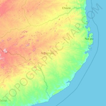
Name: Nampula Province topographic map, elevation, terrain.
Location: Nampula Province, Zona Norte, Mozambique (-16.89888 36.69551 -13.44493 40.83930)
Average elevation: 244 m
Minimum elevation: -1 m
Maximum elevation: 1,666 m
Other topographic maps
Click on a map to view its topography, its elevation and its terrain.
Xai-Xai
Mozambique > Gaza > Xai-Xai
Xai-Xai is located close to the Indian Ocean, on the Limpopo River. It is 200 kilometres (120 mi) from the capital, Maputo, and is in a wide, fertile plain where rice is grown. It is at an elevation of 32 feet (9.8 m).
Average elevation: 19 m