
Make a donation
Gear up for your next adventure:
As an Amazon Associate, this site earns from qualifying purchases at no extra cost to you.
Xai-Xai topographic map
Click on the map to display elevation.
Make a donation
Gear up for your next adventure:
As an Amazon Associate, this site earns from qualifying purchases at no extra cost to you.
Xai-Xai
Xai-Xai is located close to the Indian Ocean, on the Limpopo River. It is 200 kilometres (120 mi) from the capital, Maputo, and is in a wide, fertile plain where rice is grown. It is at an elevation of 32 feet (9.8 m).
Make a donation
Gear up for your next adventure:
As an Amazon Associate, this site earns from qualifying purchases at no extra cost to you.
About this map
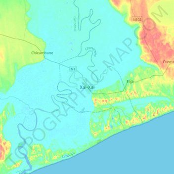
Name: Xai-Xai topographic map, elevation, terrain.
Location: Xai-Xai, Cidade de Xai-Xai, Gaza, Mozambique (-25.20448 33.48073 -24.88448 33.80073)
Average elevation: 19 m
Minimum elevation: -4 m
Maximum elevation: 132 m
Make a donation
Gear up for your next adventure:
As an Amazon Associate, this site earns from qualifying purchases at no extra cost to you.