
Sapporo topographic map
Interactive map
Click on the map to display elevation.
Sapporo
Sapporo is a city located in the southwest part of Ishikari Plain and the alluvial fan of the Toyohira River, a tributary stream of the Ishikari River. It is part of Ishikari Subprefecture. Roadways in the urban district are laid to make a grid plan. The western and southern parts of Sapporo are occupied by a number of mountains including Mount Teine, Maruyama, and Mount Moiwa, as well as many rivers including the Ishikari River, Toyohira River, and Sōsei River. Sapporo has an elevation of 29 m (95 ft 2 in).
About this map
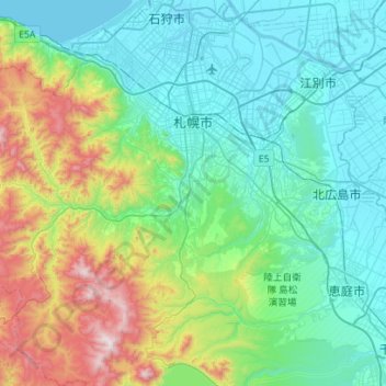
Name: Sapporo topographic map, elevation, terrain.
Location: Sapporo, Ishikari Subprefecture, Hokkaido Prefecture, Japan (42.78071 140.99050 43.18999 141.50542)
Average elevation: 273 m
Minimum elevation: -2 m
Maximum elevation: 1,299 m
Other topographic maps
Click on a map to view its topography, its elevation and its terrain.
東京湾
Japan > Kanagawa Prefecture > Kawasaki
The shoal between Cape Futtsu in Chiba Prefecture and Cape Honmaku in Yokohama is known as Nakanose, and has a depth of 20 metres (66 ft). North of this area the bay has a depth of 40 metres (130 ft) and an uncomplicated underwater topography. Areas south of Nakanose are significantly deeper moving towards the…
Average elevation: 0 m
Mount Aso
With an elevation of 1,143 metres (3,750 ft)., Mount Aso has a climate that falls as humid continental (Köppen climate classification "Dfb"), with warm summers and cold winters. Precipitation is high throughout the year, which brings the area to have borderline subtropical characteristics as well. They are…
Average elevation: 1,203 m