
Hiroshima topographic map
Interactive map
Click on the map to display elevation.
About this map
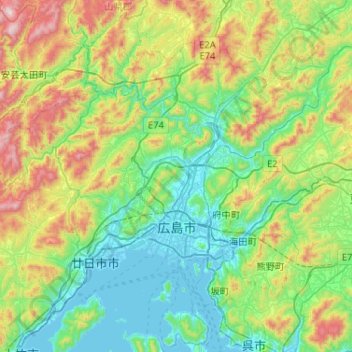
Name: Hiroshima topographic map, elevation, terrain.
Location: Hiroshima, Hiroshima Prefecture, Japan (34.28880 132.17855 34.61477 132.69610)
Average elevation: 300 m
Minimum elevation: -3 m
Maximum elevation: 1,127 m
Other topographic maps
Click on a map to view its topography, its elevation and its terrain.
東京湾
Japan > Kanagawa Prefecture > Kawasaki
The shoal between Cape Futtsu in Chiba Prefecture and Cape Honmaku in Yokohama is known as Nakanose, and has a depth of 20 metres (66 ft). North of this area the bay has a depth of 40 metres (130 ft) and an uncomplicated underwater topography. Areas south of Nakanose are significantly deeper moving towards the…
Average elevation: 0 m
Mount Aso
With an elevation of 1,143 metres (3,750 ft)., Mount Aso has a climate that falls as humid continental (Köppen climate classification "Dfb"), with warm summers and cold winters. Precipitation is high throughout the year, which brings the area to have borderline subtropical characteristics as well. They are…
Average elevation: 1,203 m