
Kitchener topographic map
Interactive map
Click on the map to display elevation.
Kitchener
Kitchener is located in Southwestern Ontario, in the Saint Lawrence Lowlands. This geological and climatic region has wet-climate soils and deciduous forests. Situated in the Grand River Valley, the area is generally above 300 m (1,000 ft) in elevation.
About this map
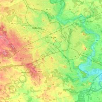
Name: Kitchener topographic map, elevation, terrain.
Location: Kitchener, Region of Waterloo, Ontario, Canada (43.35388 -80.57346 43.50683 -80.37841)
Average elevation: 336 m
Minimum elevation: 272 m
Maximum elevation: 419 m
Region of Waterloo trails, hiking, mountain biking, running and outdoor activities
Other topographic maps
Click on a map to view its topography, its elevation and its terrain.