
St. Clements topographic map
Click on the map to display elevation.
About this map
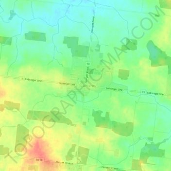
Name: St. Clements topographic map, elevation, terrain.
Average elevation: 373 m
Minimum elevation: 350 m
Maximum elevation: 405 m
Region of Waterloo trails, hiking, mountain biking, running and outdoor activities
Other topographic maps
Click on a map to view its topography, its elevation and its terrain.
Kitchener
Canada > Ontario > Region of Waterloo
Kitchener is located in Southwestern Ontario, in the Saint Lawrence Lowlands. This geological and climatic region has wet-climate soils and deciduous forests. Situated in the Grand River Valley, the area is generally above 300 m (1,000 ft) in elevation.
Average elevation: 336 m
The Township of Wilmot Arboretum
Canada > Ontario > Region of Waterloo > Wilmot > New Hamburg > Luxemburg
Average elevation: 342 m
Kitchener
Canada > Ontario > Region of Waterloo
Kitchener is located in Southwestern Ontario, in the Saint Lawrence Lowlands. This geological and climatic region has wet-climate soils and deciduous forests. Situated in the Grand River Valley, the area is generally above 300 m (1,000 ft) in elevation.
Average elevation: 336 m