
Long Beach topographic map
Interactive map
Click on the map to display elevation.
Long Beach
Willow Springs Park was founded as a part of the Willow Springs Wetlands Restoration Project which opened in October 2017. The project restored 11 acres of a 48-acre degraded oil well site into wetlands. These highlight the pivotal role the ecosystem played in the City of Long Beach’s establishment in the late 1800’s and helps preserve the site's history and unique topography. It is now at about 16 acres restored and, in August 2024, it began the process of being dedicated as a open space by the city council, which will make it the largest green space in Central Long Beach once done. It is run in collaboration with the city's office of Climate Action and Sustainability which was established in 2008 to support and advance environmental stewardship and equity in the City of Long Beach.
About this map
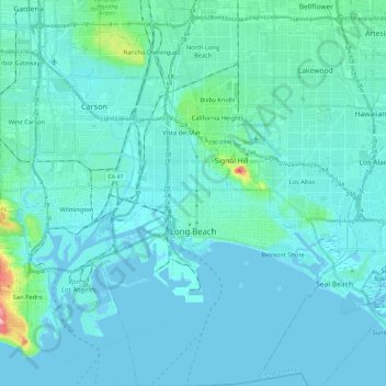
Name: Long Beach topographic map, elevation, terrain.
Location: Long Beach, Los Angeles County, California, United States (33.69058 -118.24897 33.88556 -118.06324)
Average elevation: 12 m
Minimum elevation: -5 m
Maximum elevation: 129 m
Other topographic maps
Click on a map to view its topography, its elevation and its terrain.
Calabasas Highlands
United States > California > Los Angeles County > Calabasas
Average elevation: 404 m
Point Dume
United States > California > Los Angeles County > Malibu
Offshore, the nutrient-rich and frigid waters of the Pacific enhance the entire marine food web, from primary producers such as algae and zooplankton to apex predators like sand sharks, bottlenose dolphins, and gray whales. Within the Marine Protected Areas (MPAs), the diverse seafloor topography encompasses…
Average elevation: 12 m
Hungry Valley SVRA
United States > California > Los Angeles County > Gorman
Average elevation: 1,303 m
Mount San Antonio
United States > California > Los Angeles County
The prehistoric Hog Back landslide lies in the canyon of San Antonio Creek at 4000' elevation. When the slide occurred, it dammed the river, whose depth built up until the water was released catastrophically, forming a slot canyon which now holds some of the area's few good rock climbing routes (difficulty…
Average elevation: 2,675 m
Santa Monica Mountains
United States > California > Los Angeles County
On January 17, 2007, an unusually cold storm brought snow in the Santa Monica Mountains. The hills above Malibu picked up three inches (eight centimeters) of snow - the first measurable snow in fifty years. Snow was reported on Boney Peak in the winter of 2005; and in March 2006, snow also fell on the summit…
Average elevation: 201 m
Horsethief Canyon Park
United States > California > Los Angeles County > San Dimas
Average elevation: 373 m
Malibu Vista
United States > California > Los Angeles County > Unincorporated Santa Monica Mountains
Average elevation: 283 m
Santa Susana Mountains
United States > California > Los Angeles County > Unincorporated Chatsworth
Average elevation: 546 m
Lake Elizabeth
United States > California > Los Angeles County
The lake, at 3,228 ft (984 m) in elevation, is within the Angeles National Forest. It is a natural perennial lake, but may dry up entirely during drought years. It is south of the western Antelope Valley.
Average elevation: 1,065 m
Eaton Canyon Waterfall
United States > California > Los Angeles County > Pasadena
Average elevation: 639 m
Twin Lakes
United States > California > Los Angeles County > Unincorporated Chatsworth
Average elevation: 400 m
San Fernando Valley
United States > California > Los Angeles County > Los Angeles
Average elevation: 496 m
El Escorpion Park
United States > California > Los Angeles County > Los Angeles
Average elevation: 341 m
Veterans Administration
United States > California > Los Angeles County > Veterans Administration
Average elevation: 105 m
Calabasas Highlands
United States > California > Los Angeles County > Calabasas
Average elevation: 404 m
West Puente Valley
United States > California > Los Angeles County > West Puente Valley
Average elevation: 101 m
West Puente Valley
United States > California > Los Angeles County > West Puente Valley
Average elevation: 101 m
Monte Nido
United States > California > Los Angeles County > Unincorporated Santa Monica Mountains
Average elevation: 327 m
San Pedro Hill
United States > California > Los Angeles County > Rancho Palos Verdes
Average elevation: 285 m
Briggs Terrace
United States > California > Los Angeles County > Briggs Terrace
Average elevation: 801 m
Sierra Madre
United States > California > Los Angeles County > Sierra Madre > Sierra Madre
In 1908, the first Mt. Wilson Trail Race was run. This annual race was discontinued during WWII and reestablished in 1966. The 102nd anniversary of the first running of the Mount Wilson Trail Race and the 44th annual race was run in May 2010. Because of rain, mudslides, falling trees, soil erosion and…
Average elevation: 379 m
Agua Dulce
United States > California > Los Angeles County
Agua Dulce (pronunciation) (Spanish for "Sweet Water") is a census-designated place in Los Angeles County, California, United States. It lies at an elevation of 2,526 feet (770 m), northeast of Santa Clarita. The community had a population of 3,342 at the 2010 census and covers a geographic area of about 23…
Average elevation: 803 m
Rancho Santa Clarita
United States > California > Los Angeles County > Santa Clarita > Rancho Santa Clarita
Average elevation: 397 m
Malibu Junction
United States > California > Los Angeles County > Agoura Hills
Average elevation: 320 m
Rio de Los Angeles State Park State Recreational Area
United States > California > Los Angeles County > Los Angeles
Average elevation: 141 m