
Make a donation
Gear up for your next adventure:
As an Amazon Associate, this site earns from qualifying purchases at no extra cost to you.
San Fernando Valley topographic map
Click on the map to display elevation.
Make a donation
Gear up for your next adventure:
As an Amazon Associate, this site earns from qualifying purchases at no extra cost to you.
About this map
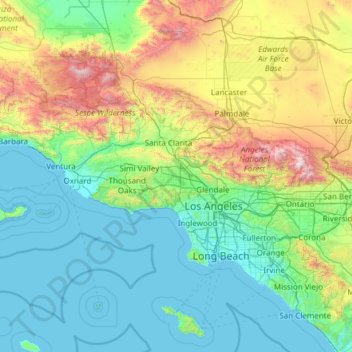
Name: San Fernando Valley topographic map, elevation, terrain.
Average elevation: 496 m
Minimum elevation: 0 m
Maximum elevation: 2,998 m
Make a donation
Gear up for your next adventure:
As an Amazon Associate, this site earns from qualifying purchases at no extra cost to you.
Other topographic maps
Click on a map to view its topography, its elevation and its terrain.
Valley Village Neighborhood Council District
United States > California > Los Angeles County > Los Angeles
Average elevation: 199 m
Make a donation
Gear up for your next adventure:
As an Amazon Associate, this site earns from qualifying purchases at no extra cost to you.
Studio City Neighborhood Council District
United States > California > Los Angeles County > Los Angeles
Average elevation: 255 m
Canoga Park Neighborhood Council District
United States > California > Los Angeles County > Los Angeles
Average elevation: 255 m
Porter Ranch Neighborhood Council District
United States > California > Los Angeles County > Los Angeles
Average elevation: 460 m
Pacific Palisades
United States > California > Los Angeles County > Los Angeles
Pacific Palisades was formally founded in 1921 by a Methodist organization, and in the years that followed became a refuge for Jewish artists and intellectuals fleeing the Holocaust. The Palisades would later be sought after by celebrities and other high-profile individuals seeking privacy. It is known for its…
Average elevation: 196 m
Make a donation
Gear up for your next adventure:
As an Amazon Associate, this site earns from qualifying purchases at no extra cost to you.
Van Nuys Neighborhood Council District
United States > California > Los Angeles County > Los Angeles
Average elevation: 224 m
Winnetka Neighborhood Council District
United States > California > Los Angeles County > Los Angeles
Average elevation: 244 m
Sherman Oaks Neighborhood Council District
United States > California > Los Angeles County > Los Angeles
Average elevation: 257 m
Make a donation
Gear up for your next adventure:
As an Amazon Associate, this site earns from qualifying purchases at no extra cost to you.
Chatsworth Neighborhood Council District
United States > California > Los Angeles County > Los Angeles
Average elevation: 360 m
North Hollywood Neighborhood Council District
United States > California > Los Angeles County > Los Angeles
Average elevation: 196 m
Encino Neighborhood Council District
United States > California > Los Angeles County > Los Angeles
Average elevation: 288 m
Make a donation
Gear up for your next adventure:
As an Amazon Associate, this site earns from qualifying purchases at no extra cost to you.
Pacoima Neighborhood Council
United States > California > Los Angeles County > Los Angeles
Average elevation: 312 m
Will Rogers State Historic Park
United States > California > Los Angeles County > Los Angeles
Average elevation: 152 m
Make a donation
Gear up for your next adventure:
As an Amazon Associate, this site earns from qualifying purchases at no extra cost to you.
Valley Village Neighborhood Council District
United States > California > Los Angeles County > Los Angeles
Average elevation: 199 m
Chatsworth Neighborhood Council District
United States > California > Los Angeles County > Los Angeles
Average elevation: 360 m
Make a donation
Gear up for your next adventure:
As an Amazon Associate, this site earns from qualifying purchases at no extra cost to you.
El Escorpion Park
United States > California > Los Angeles County > Los Angeles
Average elevation: 341 m
Chatsworth Neighborhood Council District
United States > California > Los Angeles County > Los Angeles
Average elevation: 361 m
Van Nuys Neighborhood Council District
United States > California > Los Angeles County > Los Angeles
Average elevation: 224 m
Make a donation
Gear up for your next adventure:
As an Amazon Associate, this site earns from qualifying purchases at no extra cost to you.
Chatsworth Neighborhood Council District
United States > California > Los Angeles County > Los Angeles
Average elevation: 360 m
Los Angeles City Council District 11
United States > California > Los Angeles County > Los Angeles
Average elevation: 141 m
Make a donation
Gear up for your next adventure:
As an Amazon Associate, this site earns from qualifying purchases at no extra cost to you.
North Hollywood Neighborhood Council District
United States > California > Los Angeles County > Los Angeles
Average elevation: 196 m
Chatsworth Neighborhood Council District
United States > California > Los Angeles County > Los Angeles
Average elevation: 360 m
Make a donation
Gear up for your next adventure:
As an Amazon Associate, this site earns from qualifying purchases at no extra cost to you.
Aliso Canyon Park
United States > California > Los Angeles County > Los Angeles
Average elevation: 420 m
Sherman Oaks Neighborhood Council District
United States > California > Los Angeles County > Los Angeles
Average elevation: 257 m
Hollywood Hills
United States > California > Los Angeles County > Los Angeles
Average elevation: 242 m
Make a donation
Gear up for your next adventure:
As an Amazon Associate, this site earns from qualifying purchases at no extra cost to you.
Los Angeles City Council District 7
United States > California > Los Angeles County > Los Angeles
Average elevation: 512 m
Make a donation
Gear up for your next adventure:
As an Amazon Associate, this site earns from qualifying purchases at no extra cost to you.
Rio de Los Angeles State Park State Recreational Area
United States > California > Los Angeles County > Los Angeles
Average elevation: 141 m