
Mount Tabor topographic map
Interactive map
Click on the map to display elevation.
About this map
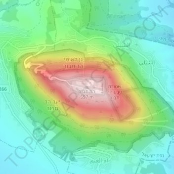
Name: Mount Tabor topographic map, elevation, terrain.
Location: Mount Tabor, North District, Israel (32.68706 35.38957 32.68716 35.38967)
Average elevation: 250 m
Minimum elevation: 101 m
Maximum elevation: 561 m
Other topographic maps
Click on a map to view its topography, its elevation and its terrain.
Safed
Safed (also known as Tzfat; Hebrew: צְפַת; Arabic: صفد, Ṣafad) is a city in the Northern District of Israel. Located at an elevation of up to 937 metres (3,074 ft), Safed is the highest city in the Galilee and in Israel. It is known as the "capital" of the Galilee.
Average elevation: 682 m
Nahal HaKibbutsim
Israel > North District > Emek HaMaayanot Regional Council
Average elevation: -101 m
Karmiel
Karmiel is located on the Acre–Safed road, on the northern edge of the Lower Galilee. It lies in the Beit HaKerem Valley and its elevation is 330 m (1,082.68 ft). The Hilazon Stream passes slightly to the south of Karmiel. Its tributaries, the Shezor and Shagor Streams pass through Karmiel on the east and…
Average elevation: 241 m
Safed
Safed (known in Hebrew as Tzfat; Sephardic Hebrew & Modern Hebrew: צְפַת Tsfat, Ashkenazi Hebrew: Tzfas, Biblical Hebrew: Ṣǝp̄aṯ; Arabic: صفد, Ṣafad),[3][4] is a city in the Northern District of Israel. Located at an elevation of 900 metres (2,953 ft), Safed is the highest city in the Galilee and in Israel.[5]
Average elevation: 549 m
Nazareth
Israel > North District > Nazareth
As of the early 1990s, no city plans drafted by Nazareth Municipality have been approved by the government (both the British Mandate and later Israel) since 1942. This has left many people in Nazareth who vote in the city's municipal elections and receive services from its municipality effectively outside of…
Average elevation: 359 m
Mishmar HaEmek
Israel > North District > Megido Regional Council > Mishmar HaEmek
Average elevation: 125 m