Geolocate

Turan topographic map

Interactive map

Click on the map to display elevation.

About this map

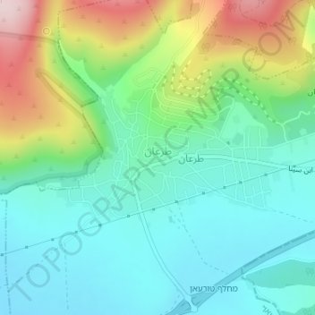
Name: Turan topographic map, elevation, terrain.

Location: Turan, Jezreel Subdistrict, North District, Israel (32.77052 35.36213 32.78279 35.38784)

Average elevation: 267 m

Minimum elevation: 171 m

Maximum elevation: 495 m

Other topographic maps

Click on a map to view its topography, its elevation and its terrain.

Safed

Israel > North District

Safed (also known as Tzfat; Hebrew: צְפַת; Arabic: صفد, Ṣafad) is a city in the Northern District of Israel. Located at an elevation of up to 937 metres (3,074 ft), Safed is the highest city in the Galilee and in Israel. It is known as the "capital" of the Galilee.

Average elevation: 682 m

Yizra'el

Israel > North District

Average elevation: 56 m

Karmiel

Israel > North District

Karmiel is located on the Acre–Safed road, on the northern edge of the Lower Galilee. It lies in the Beit HaKerem Valley and its elevation is 330 m (1,082.68 ft). The Hilazon Stream passes slightly to the south of Karmiel. Its tributaries, the Shezor and Shagor Streams pass through Karmiel on the east and…

Average elevation: 241 m

Golan Heights

Israel > North District > Golan Regional Council

The plateau that Israel controls is part of a larger area of volcanic basalt fields stretching north and east that were created in the series of volcanic eruptions that began recently in geological terms, almost 4 million years ago. The rock forming the mountainous area in the northern Golan Heights,…

Average elevation: 533 m

Metula

Israel > North District

Average elevation: 499 m

Birkat Ram

Israel > North District > Masade > Masade

Average elevation: 1,012 m

Nurit

Israel > North District > Gilboa Regional Council > Nurit

Average elevation: 96 m

Sea of Galilee

Israel > North District

After five years of drought as of 2018, Sea of Galilee is expected to get to the black line. The black elevation line is the lowest depth from which irreversible damage begins and no water can be pumped out any more. Israel Oceanographic and Limnological Research describes it as "The black line marks −214.87…

Average elevation: -67 m

2236 Mt. Hermon

Israel > North District > Golan Regional Council

Mount Hermon (Arabic: جبل الشيخ or جبل حرمون / ALA-LC: Jabal al-Shaykh ('Mountain of the Sheikh') or Jabal Haramun; Hebrew: הַר חֶרְמוֹן, Har Ḥermōn) is a mountain cluster constituting the southern end of the Anti-Lebanon mountain range. Its summit straddles the border between…

Average elevation: 2,016 m

Nazareth

Israel > North District > Nazareth

As of the early 1990s, no city plans drafted by Nazareth Municipality have been approved by the government (both the British Mandate and later Israel) since 1942. This has left many people in Nazareth who vote in the city's municipal elections and receive services from its municipality effectively outside of…

Average elevation: 151 m

Mount Tabor

Israel > North District

Average elevation: 250 m

Tiberias

Israel > North District > Tveria > Tiberias

Average elevation: -82 m

Beit Shean

Israel > North District > Beit Shean

Average elevation: -132 m

Ramat HaShofet

Israel > North District > Ramat HaShofet

Average elevation: 218 m

Nazareth

Israel > North District > Nazareth

As of the early 1990s, no city plans drafted by Nazareth Municipality have been approved by the government (both the British Mandate and later Israel) since 1942. This has left many people in Nazareth who vote in the city's municipal elections and receive services from its municipality effectively outside of…

Average elevation: 359 m

Safed

Israel > North District

Safed (known in Hebrew as Tzfat; Sephardic Hebrew & Modern Hebrew: צְפַת Tsfat, Ashkenazi Hebrew: Tzfas, Biblical Hebrew: Ṣǝp̄aṯ; Arabic: صفد, Ṣafad),[3][4] is a city in the Northern District of Israel. Located at an elevation of 900 metres (2,953 ft), Safed is the highest city in the Galilee and in Israel.[5]

Average elevation: 549 m

Zefat

Israel > North District > Zefat

Average elevation: 732 m