
Karmiel topographic map
Click on the map to display elevation.
Karmiel
Karmiel is located on the Acre–Safed road, on the northern edge of the Lower Galilee. It lies in the Beit HaKerem Valley and its elevation is 330 m (1,082.68 ft). The Hilazon Stream passes slightly to the south of Karmiel. Its tributaries, the Shezor and Shagor Streams pass through Karmiel on the east and north, respectively. Karmiel sits on the Shagor mountain range, which stretches from Mount Hazon in the east (584 m (1,916.01 ft), next to Maghar) to Mount Gilon in the west (367 m (1,204.07 ft), at Gilon). Western Karmiel was built on the Karmi (362 m) and Makosh (315 m) mountains. Work on a new railway line linking Haifa and Karmiel began in 2011 and opened in 2017.
About this map
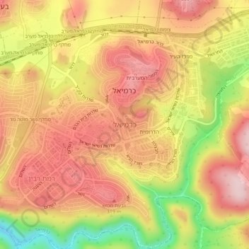
Name: Karmiel topographic map, elevation, terrain.
Location: Karmiel, Acre Subdistrict, North District, Israel (32.89765 35.26634 32.92434 35.30918)
Average elevation: 241 m
Minimum elevation: 76 m
Maximum elevation: 344 m
Other topographic maps
Click on a map to view its topography, its elevation and its terrain.
Safed
Safed (also known as Tzfat; Hebrew: צְפַת; Arabic: صفد, Ṣafad) is a city in the Northern District of Israel. Located at an elevation of up to 937 metres (3,074 ft), Safed is the highest city in the Galilee and in Israel. It is known as the "capital" of the Galilee.
Average elevation: 682 m
Golan Heights
Israel > North District > Golan Regional Council
The plateau that Israel controls is part of a larger area of volcanic basalt fields stretching north and east that were created in the series of volcanic eruptions that began recently in geological terms, almost 4 million years ago. The rock forming the mountainous area in the northern Golan Heights,…
Average elevation: 533 m
Nazareth
Israel > North District > Nazareth
As of the early 1990s, no city plans drafted by Nazareth Municipality have been approved by the government (both the British Mandate and later Israel) since 1942. This has left many people in Nazareth who vote in the city's municipal elections and receive services from its municipality effectively outside of…
Average elevation: 151 m