
Orkney Islands topographic map
Interactive map
Click on the map to display elevation.
Orkney Islands
The southern group of islands surrounds Scapa Flow. Hoy, to the west, is the second largest of the Orkney Isles and Ward Hill at its northern end is the highest elevation in the archipelago. The Old Man of Hoy is a well-known seastack. Graemsay and Flotta are both linked by ferry to the Mainland and Hoy, and the latter is known for its large oil terminal. South Walls has a 19th-century Martello tower and is connected to Hoy by the Ayre. Burray lies to the east of Scapa Flow and is linked by causeway to South Ronaldsay, which hosts cultural events the Festival of the Horse and the Boys' Ploughing Match on the third Saturday in August. It is also the location of the Neolithic Tomb of the Eagles. South Ronaldsay, Burray, Glimps Holm, and Lamb Holm are connected by road to the Mainland by the Churchill Barriers.
About this map
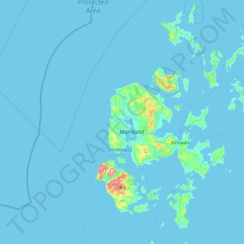
Name: Orkney Islands topographic map, elevation, terrain.
Location: Orkney Islands, Scotland, United Kingdom (58.68595 -3.43587 59.39272 -2.37048)
Average elevation: 9 m
Minimum elevation: -1 m
Maximum elevation: 468 m
Other topographic maps
Click on a map to view its topography, its elevation and its terrain.