
Ubay topographic map
Interactive map
Click on the map to display elevation.
About this map
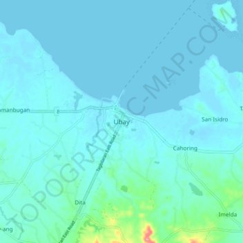
Name: Ubay topographic map, elevation, terrain.
Location: Ubay, Bohol, Central Visayas, 6315, Philippines (10.01401 124.43408 10.09401 124.51408)
Average elevation: 12 m
Minimum elevation: 0 m
Maximum elevation: 123 m
Other topographic maps
Click on a map to view its topography, its elevation and its terrain.