
Attica topographic map
Interactive map
Click on the map to display elevation.
About this map
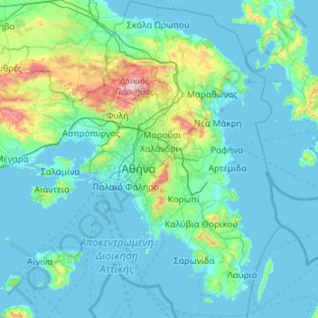
Name: Attica topographic map, elevation, terrain.
Location: Attica, Greece (37.64831 23.10669 38.34101 24.08594)
Average elevation: 133 m
Minimum elevation: -1 m
Maximum elevation: 1,384 m
Other topographic maps
Click on a map to view its topography, its elevation and its terrain.
Marathon
Greece > Attica > Regional Unit of East Attica
World records were not officially recognized by the IAAF until 1 January 2004; previously, the best times for the marathon were referred to as the 'world best'. Courses must conform to IAAF standards for a record to be recognized. However, marathon routes still vary greatly in elevation, course, and surface,…
Average elevation: 146 m