Geolocate

Kapandriti topographic map

Click on the map to display elevation.

About this map

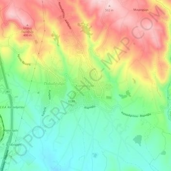
Name: Kapandriti topographic map, elevation, terrain.

Location: Kapandriti, Municipality of Oropos, Regional Unit of East Attica, Attica, 190 14, Greece (38.19587 23.85719 38.23587 23.89719)

Average elevation: 356 m

Minimum elevation: 245 m

Maximum elevation: 503 m

Other topographic maps

Click on a map to view its topography, its elevation and its terrain.

Gear up for your next adventure:

🥾Mountain Trail Shoes - High-traction shoes for mountain trails
🛰️Satellite Messenger - Emergency communication for areas with no cell service
🥾Hiking Shorts - Breathable shorts suitable for summer hikes
🎒Hiking Daypack - Lightweight and durable backpacks for day trips and excursions
🧦Crew Hiking Socks - Comfortable socks for long-distance hikes

As an Amazon Associate, this site earns from qualifying purchases at no extra cost to you.