
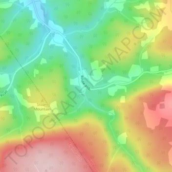
Rosevale topographic map
Interactive map
Click on the map to display elevation.
About this map
Name: Rosevale topographic map, elevation, terrain.
Average elevation: 244 m
Minimum elevation: 126 m
Maximum elevation: 387 m
New Brunswick trails, hiking, mountain biking, running and outdoor activities
Other topographic maps
Click on a map to view its topography, its elevation and its terrain.
Fredericton
Canada > New Brunswick > Kingsclear Parish > Fredericton
At an altitude of about 17 m (56 ft) above sea level, Fredericton is nestled in the Pennsylvanian Basin. It differs markedly from the geologically older parts of the province. There are prominently two distinct areas in the region that are divided around the area of Wilsey Road, in the east end of the city. In…
Average elevation: 72 m
Keswick
Canada > New Brunswick > Central York Rural Community > Douglas Parish
Average elevation: 25 m
White Rapids
Canada > New Brunswick > Rural Community of Miramichi River Valley > Blackville Parish
Average elevation: 40 m
Kingston Peninsula
Canada > New Brunswick > Fundy Rural District > Kingston Parish
Average elevation: 79 m
Grand Manan Island
Canada > New Brunswick > Village of Grand Manan > Grand Manan Parish
Average elevation: 17 m
Little River
Canada > New Brunswick > Community of Three Rivers > Town of Salisbury
Average elevation: 98 m
Edmundston
Canada > New Brunswick > City of Edmundston > Madawaska Parish
Edmundston has a downhill skiing facility in the city at Mont Farlagne. This facility has 3 lifts, a t-bar, a double chair, and a quad chair. It has 14 trails and an elevation of 690 feet. Snowmaking is available. Five trails are lit for night skiing.
Average elevation: 230 m
Manners Sutton Parish
Canada > New Brunswick > York County > Harvey Rural Community
Average elevation: 138 m
Saint John River
Canada > New Brunswick > Haut-Madawaska > Saint-Francois Parish > Saint-François-de-Madawaska
The eastern Algonquin languages had different dialects associated with each of the major river systems of New England and the Maritimes; and there was often a linguistic bifurcation between residents of the upper river and those living along the coast and tidal estuary. The Passamaquoddy hunted sea mammals…
Average elevation: 208 m
City of Saint John
Canada > New Brunswick > Saint John County
The topography surrounding Saint John is hilly; a result of the influence of two coastal mountain ranges which run along the Bay of Fundy – the St. Croix Highlands and the Caledonia Highlands. The soil throughout the region is extremely rocky with frequent granite outcrops. The coastal plain hosts numerous…
Average elevation: 36 m
Memramcook Lake
Canada > New Brunswick > Westmorland County > Dorchester Parish
Average elevation: 19 m
Edmundston
Canada > New Brunswick > Madawaska Parish
Edmundston has a downhill skiing facility in the city at Mont Farlagne. This facility has 3 lifts, a t-bar, a double chair, and a quad chair. It has 14 trails and an elevation of 690 feet. Snowmaking is available. Five trails are lit for night skiing.
Average elevation: 256 m
Fredericton
Canada > New Brunswick > York County
At an altitude of about 17 m (56 ft) above sea level, Fredericton is nestled in the Pennsylvanian Basin. It differs markedly from the geologically older parts of the province. There are prominently two distinct areas in the region that are divided around the area of Wilsey Road, in the east end of the city. In…
Average elevation: 73 m
Sugarloaf Provincial Park
Canada > New Brunswick > Addington Parish > Campbellton
Average elevation: 153 m
Fredericton
Canada > New Brunswick > York County
At an altitude of about 17 m (56 ft) above sea level, Fredericton is nestled in the Pennsylvanian Basin. It differs markedly from the geologically older parts of the province. There are prominently two distinct areas in the region that are divided around the area of Wilsey Road, in the east end of the city. In…
Average elevation: 73 m
City of Edmundston
Canada > New Brunswick > Madawaska County
Edmundston has a downhill skiing facility in the city at Mont Farlagne. This facility has 3 lifts, a t-bar, a double chair, and a quad chair. It has 14 trails and an elevation of 690 feet. Snowmaking is available. Five trails are lit for night skiing.
Average elevation: 264 m
Campobello Island
Canada > New Brunswick > Campobello Parish > Campobello Island
Average elevation: 6 m