Geolocate

Frontenac topographic map

Interactive map

Click on the map to display elevation.

About this map

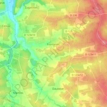
Name: Frontenac topographic map, elevation, terrain.

Location: Frontenac, Langon, Gironde, Nouvelle-Aquitaine, Metropolitan France, 33760, France (44.71140 -0.17778 44.74733 -0.10429)

Average elevation: 69 m

Minimum elevation: 19 m

Maximum elevation: 115 m

Other topographic maps

Click on a map to view its topography, its elevation and its terrain.

Manial

France > Nouvelle-Aquitaine > Gironde > Pompignac

Average elevation: 69 m

Darau

France > Nouvelle-Aquitaine > Gironde > Blasimon

Average elevation: 74 m

La Mayanne

France > Nouvelle-Aquitaine > Gironde > Francicot

Average elevation: 18 m

Laussac

France > Nouvelle-Aquitaine > Gironde > Landerrouat

Average elevation: 99 m

Carcos

France > Nouvelle-Aquitaine > Gironde > Morizès

Average elevation: 59 m

Hillan

France > Nouvelle-Aquitaine > Gironde > Belin-Béliet

Average elevation: 51 m

Genin

France > Nouvelle-Aquitaine > Gironde > Lamothe-Landerron

Average elevation: 36 m

Marandet

France > Nouvelle-Aquitaine > Gironde > Latresne

Average elevation: 14 m

Cité du Quillet

France > Nouvelle-Aquitaine > Gironde > Bazas

Average elevation: 102 m

Berquin

France > Nouvelle-Aquitaine > Gironde > Langoiran

Average elevation: 45 m

Lauros

France > Nouvelle-Aquitaine > Gironde > Le Porge

Average elevation: 15 m