
Rif Dimashq Governorate topographic map
Interactive map
Click on the map to display elevation.
About this map
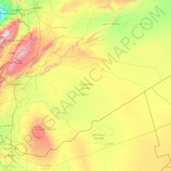
Name: Rif Dimashq Governorate topographic map, elevation, terrain.
Location: Rif Dimashq Governorate, Syria (32.69255 35.81246 34.24892 39.13386)
Average elevation: 775 m
Minimum elevation: 4 m
Maximum elevation: 3,044 m
Other topographic maps
Click on a map to view its topography, its elevation and its terrain.
Tadmur
With the elevation of Palmyra to a colonia around 213–216, the city ceased being subject to Roman provincial governors and taxes. Palmyra incorporated Roman institutions into its system while keeping many of its former ones. The council remained, and the strategos designated one of two annually-elected…
Average elevation: 499 m
Khan Shaykhun
Khan Shaykhun is located at an altitude of 350 meters on the main highway between Aleppo and Damascus. The local economy is primarily agricultural, focusing on the growing of cotton and cereals. The town was formerly known for producing embroidery. Nearby localities include Hbit to the west, Kafr Zita to…
Average elevation: 385 m
Ras Al-Ayn Subdistrict
Syria > Al-Hasaka Governorate > Ras al-Ayn > Ras-Al-Ayn
Average elevation: 368 m