Make a donation
Gear up for your next adventure:
As an Amazon Associate, this site earns from qualifying purchases at no extra cost to you.
Al-Atareb topographic map
Click on the map to display elevation.
Make a donation
Gear up for your next adventure:
As an Amazon Associate, this site earns from qualifying purchases at no extra cost to you.
About this map
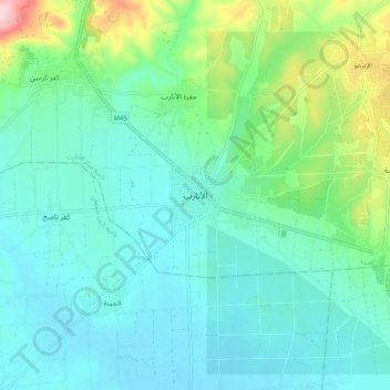
Name: Al-Atareb topographic map, elevation, terrain.
Location: Al-Atareb, Al-Atareb Subdistrict, Al-Atareb District, Syria (36.09937 36.78348 36.17937 36.86348)
Average elevation: 338 m
Minimum elevation: 286 m
Maximum elevation: 531 m
Make a donation
Gear up for your next adventure:
As an Amazon Associate, this site earns from qualifying purchases at no extra cost to you.
Other topographic maps
Click on a map to view its topography, its elevation and its terrain.
Aleppo Governorate
The average elevation of the terrain is 379 metres (1,243 ft). The surface gradually slopes down in north-south and west-east directions, undulating gently with an amplitude of 10–30 m for each wave. The lowlands are covered with combined Paleozoic and Mesozoic sediments that average 4–5 km in thickness…
Average elevation: 439 m
Make a donation
Gear up for your next adventure:
As an Amazon Associate, this site earns from qualifying purchases at no extra cost to you.
Make a donation
Gear up for your next adventure:
As an Amazon Associate, this site earns from qualifying purchases at no extra cost to you.
