
Clear Lake topographic map
Interactive map
Click on the map to display elevation.
About this map
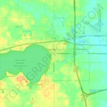
Name: Clear Lake topographic map, elevation, terrain.
Location: Clear Lake, Cerro Gordo County, Iowa, 50428, United States (43.10469 -93.43827 43.16273 -93.32001)
Average elevation: 373 m
Minimum elevation: 357 m
Maximum elevation: 398 m
Other topographic maps
Click on a map to view its topography, its elevation and its terrain.
Clear Lake
United States > Iowa > Cerro Gordo County > Clear Lake > Clear Lake
Average elevation: 373 m