
Conne River topographic map
Interactive map
Click on the map to display elevation.
About this map
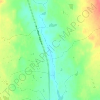
Name: Conne River topographic map, elevation, terrain.
Location: Conne River, Newfoundland, Newfoundland and Labrador, Canada (48.20806 -55.49032 48.21262 -55.48772)
Average elevation: 200 m
Minimum elevation: 173 m
Maximum elevation: 241 m
Newfoundland and Labrador trails, hiking, mountain biking, running and outdoor activities
Other topographic maps
Click on a map to view its topography, its elevation and its terrain.
Avalon Peninsula
Canada > Newfoundland and Labrador > Spaniard's Bay > Tilton
Average elevation: 157 m
Portugal Cove
Canada > Newfoundland and Labrador > Portugal Cove - St. Philips
Average elevation: 61 m