
Door County topographic map
Interactive map
Click on the map to display elevation.
Door County
The 102-foot-high (31 m) Brussels Hill (44°45′06″N 87°35′27″W / 44.75166°N 87.59093°W / 44.75166; -87.59093 (Brussels Hill), elevation 851 feet [259 m]) is the highest point in the county. The nearby Red Hill Woods is the largest remaining maple–beech forest in the area.
About this map
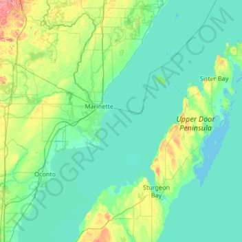
Name: Door County topographic map, elevation, terrain.
Location: Door County, Wisconsin, United States (44.67496 -87.73686 45.42985 -86.76408)
Average elevation: 191 m
Minimum elevation: 172 m
Maximum elevation: 315 m
Other topographic maps
Click on a map to view its topography, its elevation and its terrain.
Halls Lake
United States > Wisconsin > Florence County > Town of Commonwealth
Average elevation: 404 m
Kettle Moraine State Forest- Pike Lake Unit
United States > Wisconsin > Washington County > Hartford
Average elevation: 324 m