
Ethiopian Highlands topographic map
Interactive map
Click on the map to display elevation.
About this map
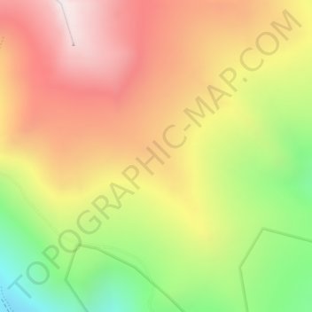
Name: Ethiopian Highlands topographic map, elevation, terrain.
Location: Ethiopian Highlands, North Gonder, Amhara Region, Ethiopia (13.21794 38.38668 13.21804 38.38678)
Average elevation: 4,164 m
Minimum elevation: 3,704 m
Maximum elevation: 4,505 m
Other topographic maps
Click on a map to view its topography, its elevation and its terrain.
Bahir Dar Special Zone
Bahir Dar is located at the exit of the Abbay from Lake Tana at an altitude of 1,820 metres (5,970 ft) above sea level. The city is located approximately 578 km north-northwest of Addis Ababa. The Lake Tana region is a UNESCO Biosphere Reserve since 2015.
Average elevation: 1,794 m
Yangudi Rassa National Park
Its 4,731 square kilometres (1,827 sq mi) of territory include Mount Yangudi (1,383 m or 4,537 ft) near the southern boundary and the surrounding Rassa Plains, with altitudes from 400 to 1,459 m (1,312 to 4,787 ft) above sea level. The Awash River flows through the park from south to north.
Average elevation: 622 m
Amhara Region
The Amhara region has the most world heritage sites of any region in Ethiopia and is endowed with natural and geographic wonders and ecosystems. The region contains Ethiopia's largest inland body of water Lake Tana, which is the source of the Blue Nile river. In 2015 Lake Tana was recognized as a UNESCO…
Average elevation: 1,618 m
Tigray
Of the 10 largest cities in Tigray, Maychew has the highest elevation at 2479 meter above sea level. Plenty of smaller towns, like Atsbi and Edaga Hamus are located at even higher elevations. Of the large cities, Humera is located at the lowest altitude (585 m).
Average elevation: 1,346 m
Mek'elē
Mekelle (Tigrinya: መቐለ, Amharic: መቀሌ, romanized: mäqälle, mek’elē) or Mekele is a special zone and capital of the Tigray Region of Ethiopia. Mekelle was formerly the capital of Enderta awraja in Tigray. It is located around 780 kilometres (480 mi) north of the Ethiopian capital Addis Ababa,…
Average elevation: 2,090 m
Blue Nile
Although there are several feeder streams that flow into Lake Tana, the sacred source of the river is generally considered to be a small spring at Gish Abay, situated at an elevation of approximately 2,744 metres (9,003 ft). This stream, known as the Gilgel Abay (Lesser Abay River), flows north into Lake Tana.…
Average elevation: 1,647 m
Gambela Region
Anywaa zone is by far the largest of the zones of Gambela Region and also includes the capital, Gambela. The terrain is mostly flat at elevations between 400 – 550 meters above sea level but with the eastern fringes of Anywaa zone and in particular the easternmost zone, Majang, being partly in the highlands…
Average elevation: 689 m
Nech Sar National Park
Ethiopia > Southern Nations, Nationalities, and Peoples > Arba Minch
Average elevation: 1,215 m