
Make a donation
Gear up for your next adventure:
As an Amazon Associate, this site earns from qualifying purchases at no extra cost to you.
Yangudi Rassa National Park topographic map
Click on the map to display elevation.
Make a donation
Gear up for your next adventure:
As an Amazon Associate, this site earns from qualifying purchases at no extra cost to you.
Yangudi Rassa National Park
Its 4,731 square kilometres (1,827 sq mi) of territory include Mount Yangudi (1,383 m or 4,537 ft) near the southern boundary and the surrounding Rassa Plains, with altitudes from 400 to 1,459 m (1,312 to 4,787 ft) above sea level. The Awash River flows through the park from south to north.
Make a donation
Gear up for your next adventure:
As an Amazon Associate, this site earns from qualifying purchases at no extra cost to you.
About this map
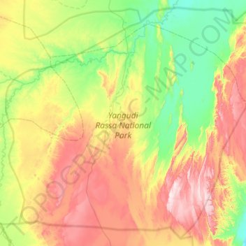
Name: Yangudi Rassa National Park topographic map, elevation, terrain.
Location: Yangudi Rassa National Park, Afar Region, Ethiopia (10.67877 40.45691 11.23814 41.06262)
Average elevation: 622 m
Minimum elevation: 408 m
Maximum elevation: 967 m
Make a donation
Gear up for your next adventure:
As an Amazon Associate, this site earns from qualifying purchases at no extra cost to you.
Other topographic maps
Click on a map to view its topography, its elevation and its terrain.
Make a donation
Gear up for your next adventure:
As an Amazon Associate, this site earns from qualifying purchases at no extra cost to you.