
Make a donation
Gear up for your next adventure:
As an Amazon Associate, this site earns from qualifying purchases at no extra cost to you.
Orange Lake topographic map
Click on the map to display elevation.
Make a donation
Gear up for your next adventure:
As an Amazon Associate, this site earns from qualifying purchases at no extra cost to you.
About this map
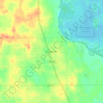
Name: Orange Lake topographic map, elevation, terrain.
Location: Orange Lake, Marion County, Florida, 32681, United States (29.40358 -82.23676 29.44358 -82.19676)
Average elevation: 32 m
Minimum elevation: 8 m
Maximum elevation: 61 m
Make a donation
Gear up for your next adventure:
As an Amazon Associate, this site earns from qualifying purchases at no extra cost to you.
Other topographic maps
Click on a map to view its topography, its elevation and its terrain.
Make a donation
Gear up for your next adventure:
As an Amazon Associate, this site earns from qualifying purchases at no extra cost to you.
Rainbow Springs State Park
United States > Florida > Marion County > Rainbow Falls
Average elevation: 21 m