Geolocate

Griegos topographic map

Click on the map to display elevation.

About this map

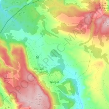
Name: Griegos topographic map, elevation, terrain.

Location: Griegos, Sierra de Albarracín, Teruel, Aragon, 44114, Spain (40.41035 -1.76239 40.47546 -1.67924)

Average elevation: 1,655 m

Minimum elevation: 1,499 m

Maximum elevation: 1,846 m

Other topographic maps

Click on a map to view its topography, its elevation and its terrain.

Caimodorro

Spain > Aragon > Sierra de Albarracín > Albarracín

Average elevation: 1,752 m

Muela de San Juan

Spain > Aragon > Sierra de Albarracín > Griegos

Average elevation: 1,735 m

Gear up for your next adventure:

🧢Outdoor Visor - Breathable visor for sunny hikes
🚲Handlebar Phone Mount - View topographic-map.com live while cycling
🧢Hiking Sun Hat - Wide-brimmed protection for exposed mountain ridges
💡Solar Camping Lamp - Eco-friendly lighting for campsites
🧢Beanie Hat - Keep your head warm in cold weather

As an Amazon Associate, this site earns from qualifying purchases at no extra cost to you.