Geolocate

Galma topographic map

Click on the map to display elevation.

About this map

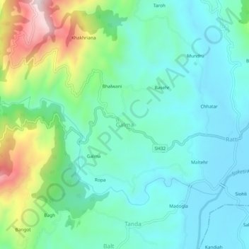
Name: Galma topographic map, elevation, terrain.

Location: Galma, Mandi, Himachal Pradesh, 175008, India (31.58316 76.86082 31.62316 76.90082)

Average elevation: 897 m

Minimum elevation: 778 m

Maximum elevation: 1,253 m

Other topographic maps

Click on a map to view its topography, its elevation and its terrain.

Beas River

India > Himachal Pradesh > Mandi > Pandoh

Average elevation: 962 m

Gear up for your next adventure:

🧰Survival Kit - Essential gear for emergencies in the wilderness
🕶️Polarized Sunglasses - Reduces glare from snow and water at high elevations
🕯️Camping Lantern - Illuminates your entire campsite with high-efficiency LEDs
👟Sport Hiking Sandals - Breathable footwear for water crossings and camp rest
Camping Tent - Weather-resistant tents suitable for 2 to 6 people

As an Amazon Associate, this site earns from qualifying purchases at no extra cost to you.