
Make a donation
Gear up for your next adventure:
As an Amazon Associate, this site earns from qualifying purchases at no extra cost to you.
Crana topographic map
Click on the map to display elevation.
Make a donation
Gear up for your next adventure:
As an Amazon Associate, this site earns from qualifying purchases at no extra cost to you.
About this map
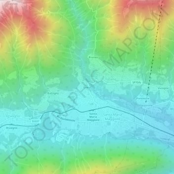
Name: Crana topographic map, elevation, terrain.
Average elevation: 1,065 m
Minimum elevation: 749 m
Maximum elevation: 1,898 m
Make a donation
Gear up for your next adventure:
As an Amazon Associate, this site earns from qualifying purchases at no extra cost to you.
Other topographic maps
Click on a map to view its topography, its elevation and its terrain.
Val Vigezzo
Italia > Piemonte > Verbano-Cusio-Ossola > Santa Maria Maggiore
Il territorio presenta una ricca vegetazione ed abbondanza di acque, nonostante la modesta altitudine delle montagne circostanti e quindi l'assenza di ghiacciai o nevai.
Average elevation: 1,368 m