Geolocate

Worcester topographic map

Click on the map to display elevation.

About this map

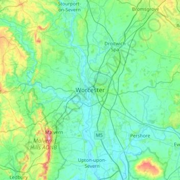
Name: Worcester topographic map, elevation, terrain.

Location: Worcester, Worcester, England, Worcestershire, West Midlands, England, WR1 2ZB, United Kingdom (52.03118 -2.38066 52.35118 -2.06066)

Average elevation: 72 m

Minimum elevation: 9 m

Maximum elevation: 422 m

Other topographic maps

Click on a map to view its topography, its elevation and its terrain.

Gear up for your next adventure:

🥾Trail Hiking Boots - Supportive boots for rough trails
🧣Merino Neck Gaiter - Protects against wind, sun, and cold at high altitudes
🧤Thermal Hiking Gloves - Grip-enhanced gloves for cold-weather altitude trekking
🧥Waterproof Jacket - Lightweight rain jackets for hiking and outdoor activities
🧦Thermal Socks - Warm socks for winter hiking or camping

As an Amazon Associate, this site earns from qualifying purchases at no extra cost to you.