
Make a donation
Gear up for your next adventure:
As an Amazon Associate, this site earns from qualifying purchases at no extra cost to you.
Damme topographic map
Click on the map to display elevation.
Make a donation
Gear up for your next adventure:
As an Amazon Associate, this site earns from qualifying purchases at no extra cost to you.
Damme
In der Nacht vom 16. auf den 17. August 1974 wurden Damme und die benachbarten Gemeinden von einem achtstündigen Dauergewitter heimgesucht. Dabei fielen Hagelkörner bis zu einer Größe von Billardkugeln und richteten Schäden in Millionenhöhe an.
Make a donation
Gear up for your next adventure:
As an Amazon Associate, this site earns from qualifying purchases at no extra cost to you.
About this map
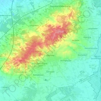
Name: Damme topographic map, elevation, terrain.
Location: Damme, Landkreis Vechta, Niedersachsen, 49401, Deutschland (52.47796 8.12643 52.57787 8.34973)
Average elevation: 61 m
Minimum elevation: 31 m
Maximum elevation: 143 m
Make a donation
Gear up for your next adventure:
As an Amazon Associate, this site earns from qualifying purchases at no extra cost to you.
Other topographic maps
Click on a map to view its topography, its elevation and its terrain.
Make a donation
Gear up for your next adventure:
As an Amazon Associate, this site earns from qualifying purchases at no extra cost to you.
Make a donation
Gear up for your next adventure:
As an Amazon Associate, this site earns from qualifying purchases at no extra cost to you.
Severinghausen
Deutschland > Niedersachsen > Landkreis Vechta > Neuenkirchen-Vörden
Average elevation: 59 m
Haverbeck
Deutschland > Niedersachsen > Landkreis Vechta > Damme > Langenteilen
Average elevation: 51 m
Rüschendorf
Deutschland > Niedersachsen > Landkreis Vechta > Damme > Rüschendorf
Average elevation: 50 m
Make a donation
Gear up for your next adventure:
As an Amazon Associate, this site earns from qualifying purchases at no extra cost to you.
Langenteilen
Deutschland > Niedersachsen > Landkreis Vechta > Damme > Langenteilen
Average elevation: 47 m
Nellinghof
Deutschland > Niedersachsen > Landkreis Vechta > Neuenkirchen-Vörden
Average elevation: 51 m
Make a donation
Gear up for your next adventure:
As an Amazon Associate, this site earns from qualifying purchases at no extra cost to you.