
Thank you for supporting this site ❤️
Make a donation
Make a donation
Gear up for your next adventure:
As an Amazon Associate, this site earns from qualifying purchases at no extra cost to you.
Rüschendorf topographic map
Click on the map to display elevation.
Thank you for supporting this site ❤️
Make a donation
Make a donation
Gear up for your next adventure:
As an Amazon Associate, this site earns from qualifying purchases at no extra cost to you.
About this map
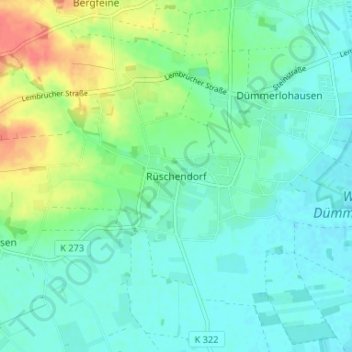
Name: Rüschendorf topographic map, elevation, terrain.
Location: Rüschendorf, Damme, Landkreis Vechta, Niedersachsen, Deutschland (52.50180 8.24600 52.54180 8.28600)
Average elevation: 50 m
Minimum elevation: 36 m
Maximum elevation: 85 m
Thank you for supporting this site ❤️
Make a donation
Make a donation
Gear up for your next adventure:
As an Amazon Associate, this site earns from qualifying purchases at no extra cost to you.