
Harlösa topographic map
Click on the map to display elevation.
About this map
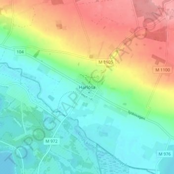
Name: Harlösa topographic map, elevation, terrain.
Location: Harlösa, Eslövs kommun, Skåne län, 241 65, Sverige (55.69761 13.50561 55.73761 13.54561)
Average elevation: 54 m
Minimum elevation: 16 m
Maximum elevation: 123 m
Other topographic maps
Click on a map to view its topography, its elevation and its terrain.
Malmö
Kring sekelskiftet skedde stora kommunala satsningar, som tillkomsten av elektricitetsverk och ett nytt gasverk. Man elektrifierade hästspårvägen, byggde ut kloakverket och inrättade ett kommunalt slakthus. En stor höjdpunkt var Baltiska utställningen 1914, vilken hölls på platsen för nuvarande…
Average elevation: 10 m
Kävlinge kommun
Majoriteten av landskapet består av en slättbygd som är svagt kuperad, den är täckt med mycket god åkerjord. Dominerande inslag i landskapsbilden är Kävlingeåns (Lödde å) dalgång i söder och Saxåns dalstråk i norr. Ett antal höjdryggar, däribland Gillhögs backe, Karabys backar och Dagstorps…
Average elevation: 16 m
Perstorps kommun
Kommunen är belägen inom norra Skånes urbergsområde. Dess landskap är varierat och utgörs av växlande små åkerfält, betesmarker och bok- och ekklädda kullar. Topografin är småskalig och moränterrängen kuperad och bitvis täckt med breda stråk av isälvsavlagringar. Barrblandskog dominerar i…
Average elevation: 100 m
Ystads kommun
Kommunen har en kustremsa mot Östersjön. Där är landskapet relativt flackt, med en höjdskillnad på omkring 50 meter som generellt lutar åt sydost mot kusten. Kustområden kring hamnen, östra delarna av centralorten och Ystads sandskog är belägna under +5 meter. Längs kusten råder ibland starka…
Average elevation: 22 m
Kullaberg
Bergskammen (och reservaten) sträcker sig från Kullanäs (vid Kullens fyr) i nordväst till Arild i sydöst, en sträcka på knappt åtta kilometer. Kullaberg är som bredast 1,5 kilometer vid Kockenhus och Björkeröd. Ytan är 932 hektar. Från berggrundsgeologisk synpunkt sträcker sig dock Kullaberg ner…
Average elevation: 22 m
Söderåsen
Kvärkadalen och Skäralid bildar tillsammans en genombrottsdal som skär genom Söderåsen i Skåne. Detta förklaras med att under Paleogentiden var Skåne och Söderåsen täckt med sediment som sedan eroderades så att floder skar ner i en topografi olik dagens.
Average elevation: 85 m
Romeleåsen
Romeleklint, 175 meter över havet, är åsens mest framträdande höjd. En lättåtkomlig höjd med vid utsikt mot väster och söder är Stenberget utefter väg 102, nära Kläggeröd. I närheten finns dagbrott med brytning av sten och morän.
Average elevation: 64 m
Kullaberg
Bergskammen (och reservaten) sträcker sig från Kullanäs (vid Kullens fyr) i nordväst till Arild i sydöst, en sträcka på knappt åtta kilometer. Kullaberg är som bredast 1,5 kilometer vid Kockenhus och Björkeröd. Ytan är 932 hektar. Från berggrundsgeologisk synpunkt sträcker sig dock Kullaberg ner…
Average elevation: 21 m
Romeleåsen
Romeleklint, 175 meter över havet, är åsens mest framträdande höjd. En lättåtkomlig höjd med vid utsikt mot väster och söder är Stenberget utefter väg 102, nära Kläggeröd. I närheten finns dagbrott med brytning av sten och morän.
Average elevation: 64 m
Malmö
Kring sekelskiftet skedde stora kommunala satsningar, som tillkomsten av elektricitetsverk och ett nytt gasverk. Man elektrifierade hästspårvägen, byggde ut kloakverket och inrättade ett kommunalt slakthus. En stor höjdpunkt var Baltiska utställningen 1914, vilken hölls på platsen för nuvarande…
Average elevation: 10 m