Geolocate

Belfast topographic map

Click on the map to display elevation.

About this map

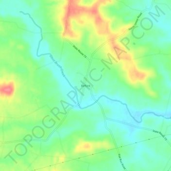
Name: Belfast topographic map, elevation, terrain.

Location: Belfast, Highland County, Ohio, United States (39.04285 -83.55242 39.08285 -83.51242)

Average elevation: 267 m

Minimum elevation: 241 m

Maximum elevation: 313 m

Other topographic maps

Click on a map to view its topography, its elevation and its terrain.

Rocky Fork Lake

United States > Ohio > Highland County

Average elevation: 291 m

Lynchburg

United States > Ohio > Highland County

Average elevation: 310 m

Hillsboro

United States > Ohio > Highland County

Average elevation: 313 m

Highland

United States > Ohio > Highland County

Average elevation: 326 m

Paint Creek Lake

United States > Ohio > Highland County

Average elevation: 277 m

Mowrystown

United States > Ohio > Highland County

Average elevation: 299 m

Gear up for your next adventure:

🥾Waterproof Hiking Shoes - Durable shoes for wet and rugged trails
🚲Heavy Duty Bike Lock - Secure your bike at the trailhead or during stops
🛏️Camping Sleeping Mat - Comfortable mats for sleeping outdoors
🛌Down Sleeping Bag - Superior warmth-to-weight ratio for cold nights
🧰Emergency Multi-Tool - Compact multi-tool for outdoor survival

As an Amazon Associate, this site earns from qualifying purchases at no extra cost to you.