Geolocate

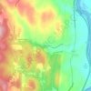
Whitingham topographic map

Click on the map to display elevation.

About this map
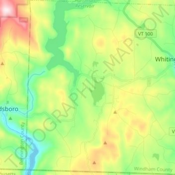
Name: Whitingham topographic map, elevation, terrain.

Location: Whitingham, Windham County, Vermont, United States (42.73641 -72.93010 42.82981 -72.80305)

Average elevation: 539 m

Minimum elevation: 334 m

Maximum elevation: 904 m

Other topographic maps

Click on a map to view its topography, its elevation and its terrain.
West Dover

United States > Vermont > Windham County > Dover

Average elevation: 583 m

Mount Snow

United States > Vermont > Windham County

Average elevation: 864 m

Williamsville

United States > Vermont > Windham County > Newfane

Average elevation: 270 m

East Dover

United States > Vermont > Windham County > Dover

Average elevation: 425 m

Williamsville

United States > Vermont > Windham County > Newfane

Average elevation: 270 m

Kenny Pond Dam

United States > Vermont > Windham County > Newfane

Average elevation: 413 m

South Newfane

United States > Vermont > Windham County > Newfane

Average elevation: 321 m

West Guilford

United States > Vermont > Windham County > Guilford

Average elevation: 344 m

Mount Snow

United States > Vermont > Windham County

Average elevation: 865 m

East Dover

United States > Vermont > Windham County > Dover

Average elevation: 425 m

Packer Corner

United States > Vermont > Windham County > Guilford

Average elevation: 305 m

Gear up for your next adventure:

🦯Trekking Poles - Reduced impact on joints for steep topographic climbs
🥾Waterproof Trail Shoes - Shoes designed to handle wet terrain
🔋Solar Power Bank - Keep your GPS and devices charged during long outdoor trips
🧢Sun Protection Cap - Breathable cap to protect from sun exposure
🧦Merino Wool Socks - Moisture-wicking comfort for long-distance hiking

As an Amazon Associate, this site earns from qualifying purchases at no extra cost to you.