
Make a donation
Gear up for your next adventure:
As an Amazon Associate, this site earns from qualifying purchases at no extra cost to you.
Olivette topographic map
Click on the map to display elevation.
Make a donation
Gear up for your next adventure:
As an Amazon Associate, this site earns from qualifying purchases at no extra cost to you.
Olivette
Olivette has one of the highest elevations in St. Louis County at 700 feet.
Make a donation
Gear up for your next adventure:
As an Amazon Associate, this site earns from qualifying purchases at no extra cost to you.
About this map
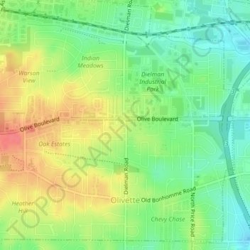
Name: Olivette topographic map, elevation, terrain.
Location: Olivette, Saint Louis County, Missouri, 63132, United States (38.66075 -90.39438 38.68599 -90.36002)
Average elevation: 194 m
Minimum elevation: 167 m
Maximum elevation: 226 m
Make a donation
Gear up for your next adventure:
As an Amazon Associate, this site earns from qualifying purchases at no extra cost to you.
Other topographic maps
Click on a map to view its topography, its elevation and its terrain.
Make a donation
Gear up for your next adventure:
As an Amazon Associate, this site earns from qualifying purchases at no extra cost to you.
Make a donation
Gear up for your next adventure:
As an Amazon Associate, this site earns from qualifying purchases at no extra cost to you.
Clarkson Valley
United States > Missouri > Saint Louis County > Clarkson Valley
Average elevation: 195 m
University City
United States > Missouri > Saint Louis County > University City > University City
Average elevation: 170 m
Make a donation
Gear up for your next adventure:
As an Amazon Associate, this site earns from qualifying purchases at no extra cost to you.
Town and Country
United States > Missouri > Saint Louis County > Town and Country > Town and Country
Average elevation: 178 m