Geolocate

Våxtorp topographic map

Click on the map to display elevation.

About this map

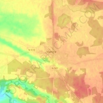
Name: Våxtorp topographic map, elevation, terrain.

Location: Våxtorp, Laholms kommun, Halland County, Sweden (56.39930 13.09590 56.43930 13.13590)

Average elevation: 45 m

Minimum elevation: 8 m

Maximum elevation: 63 m

Other topographic maps

Click on a map to view its topography, its elevation and its terrain.

Kungsbacka kommun

Sweden > Halland County

Average elevation: 41 m

Halmstads kommun

Sweden > Halland County

Average elevation: 65 m

Hylte kommun

Sweden > Halland County

Average elevation: 145 m

Vendelsö

Sweden > Halland County

Average elevation: 2 m

Laholms kommun

Sweden > Halland County

Average elevation: 98 m

Gällarpesjön

Sweden > Halland County

Average elevation: 104 m

Bocksjö

Sweden > Halland County

Average elevation: 75 m

Tjolöholms slott

Sweden > Halland County

Average elevation: 3 m

Varbergs kommun

Sweden > Halland County

Average elevation: 35 m

Gear up for your next adventure:

🥾Hiking Boots - Sturdy boots providing ankle support and traction on rugged trails
🧭GPS Outdoor Watch - Smart watch for navigation and fitness tracking in nature
❄️Traction Ice Cleats - Slip-on spikes for icy trails and winter hiking
🧥Insulated Jacket - Keep warm in cold outdoor conditions
💡Solar Camping Lamp - Eco-friendly lighting for campsites

As an Amazon Associate, this site earns from qualifying purchases at no extra cost to you.