
Make a donation
Gear up for your next adventure:
As an Amazon Associate, this site earns from qualifying purchases at no extra cost to you.
Piedmont topographic map
Click on the map to display elevation.
Make a donation
Gear up for your next adventure:
As an Amazon Associate, this site earns from qualifying purchases at no extra cost to you.
About this map
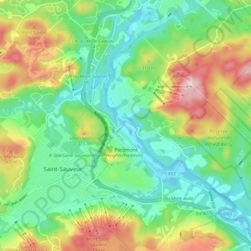
Name: Piedmont topographic map, elevation, terrain.
Location: Piedmont, Les Pays-d'en-Haut, Laurentides, Québec, Canada (45.87299 -74.15425 45.93782 -74.07082)
Average elevation: 254 m
Minimum elevation: 154 m
Maximum elevation: 443 m
Make a donation
Gear up for your next adventure:
As an Amazon Associate, this site earns from qualifying purchases at no extra cost to you.
Other topographic maps
Click on a map to view its topography, its elevation and its terrain.
Mont Jacqueline
Canada > Québec > Les Pays-d'en-Haut > Sainte-Marguerite-du-Lac-Masson
Average elevation: 346 m
Make a donation
Gear up for your next adventure:
As an Amazon Associate, this site earns from qualifying purchases at no extra cost to you.
Lac des Seigneurs
Canada > Québec > Les Pays-d'en-Haut > Sainte-Anne-des-Lacs
Average elevation: 313 m
Make a donation
Gear up for your next adventure:
As an Amazon Associate, this site earns from qualifying purchases at no extra cost to you.
Lac Saint-Louis
Canada > Québec > Les Pays-d'en-Haut > Sainte-Marguerite-du-Lac-Masson
Average elevation: 443 m
Make a donation
Gear up for your next adventure:
As an Amazon Associate, this site earns from qualifying purchases at no extra cost to you.
Make a donation
Gear up for your next adventure:
As an Amazon Associate, this site earns from qualifying purchases at no extra cost to you.
Lac de la Borne
Canada > Québec > Les Pays-d'en-Haut > Saint-Adolphe-d'Howard
Average elevation: 459 m
Make a donation
Gear up for your next adventure:
As an Amazon Associate, this site earns from qualifying purchases at no extra cost to you.
Lac Sainte-Marie
Canada > Québec > Les Pays-d'en-Haut > Saint-Adolphe-d'Howard
Average elevation: 401 m
Make a donation
Gear up for your next adventure:
As an Amazon Associate, this site earns from qualifying purchases at no extra cost to you.
Lac Marier
Canada > Québec > Les Pays-d'en-Haut > Sainte-Marguerite-du-Lac-Masson
Average elevation: 377 m