
Make a donation
Gear up for your next adventure:
As an Amazon Associate, this site earns from qualifying purchases at no extra cost to you.
Lac Sainte-Marie topographic map
Click on the map to display elevation.
Make a donation
Gear up for your next adventure:
As an Amazon Associate, this site earns from qualifying purchases at no extra cost to you.
About this map
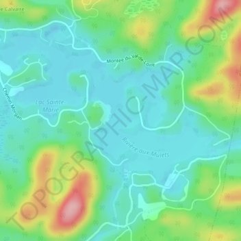
Name: Lac Sainte-Marie topographic map, elevation, terrain.
Average elevation: 401 m
Minimum elevation: 358 m
Maximum elevation: 510 m
Make a donation
Gear up for your next adventure:
As an Amazon Associate, this site earns from qualifying purchases at no extra cost to you.
Other topographic maps
Click on a map to view its topography, its elevation and its terrain.
Make a donation
Gear up for your next adventure:
As an Amazon Associate, this site earns from qualifying purchases at no extra cost to you.
Lac de la Cabane
Canada > Québec > Les Pays-d'en-Haut > Saint-Adolphe-d'Howard
Average elevation: 417 m
Lac de la Borne
Canada > Québec > Les Pays-d'en-Haut > Saint-Adolphe-d'Howard
Average elevation: 459 m
Make a donation
Gear up for your next adventure:
As an Amazon Associate, this site earns from qualifying purchases at no extra cost to you.