
Floreffe topographic map
Interactive map
Click on the map to display elevation.
About this map
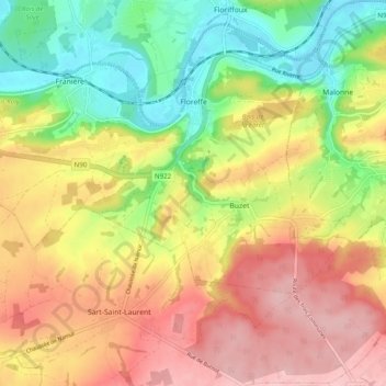
Name: Floreffe topographic map, elevation, terrain.
Location: Floreffe, Namen, Wallonië, België (50.39288 4.73166 50.45093 4.82961)
Average elevation: 173 m
Minimum elevation: 80 m
Maximum elevation: 264 m
Floreffe is een plaats en gemeente in de provincie Namen in België. De gemeente telt ruim 8.000 inwoners en ligt op een hoogte van 160 meter.
Other topographic maps
Click on a map to view its topography, its elevation and its terrain.