
Picayune topographic map
Click on the map to display elevation.
Picayune
Picayune occupies a low, gently undulating landscape in southern Pearl River County, within Mississippi’s Gulf Coastal Plain, where the terrain is marked by faint relief, sandy and clayey soils, and broad, poorly drained lowlands associated with marshy or swampy tracts. The city’s elevation is modest—around 73 ft (22 m) in general references, with the local surface shown here varying roughly from near 7 ft to 125 ft (2 m to 38 m)—and the highest ground tends to form subdued rises and interfluves to the north and east, while lower areas follow the drainage corridors of Mill Creek, East Hobolochitto Creek, Bay Branch, and the nearby Pearl River lowlands. Overall, Picayune’s physical character is that of a humid coastal-plain town: mostly flat to softly rolling, with shallow elevation gradients, stream-cut swales, floodplain margins, and pine-covered sandy uplands creating a landscape where drainage patterns and floodplain topography are more defining than steep slopes or prominent hills.
About this map
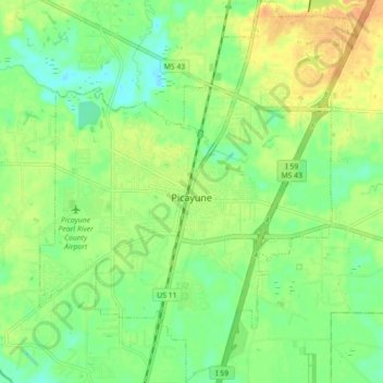
Name: Picayune topographic map, elevation, terrain.
Location: Picayune, Pearl River County, Mississippi, United States (30.48851 -89.71472 30.56469 -89.64188)
Average elevation: 19 m
Minimum elevation: 3 m
Maximum elevation: 38 m
Other topographic maps
Click on a map to view its topography, its elevation and its terrain.