
Henleyfield topographic map
Click on the map to display elevation.
About this map
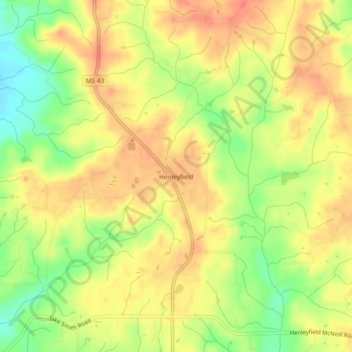
Name: Henleyfield topographic map, elevation, terrain.
Location: Henleyfield, Pearl River County, Mississippi, United States (30.67713 -89.78396 30.71713 -89.74396)
Average elevation: 56 m
Minimum elevation: 25 m
Maximum elevation: 75 m
Other topographic maps
Click on a map to view its topography, its elevation and its terrain.
Picayune
United States > Mississippi > Pearl River County
Picayune occupies a low, gently undulating landscape in southern Pearl River County, within Mississippi’s Gulf Coastal Plain, where the terrain is marked by faint relief, sandy and clayey soils, and broad, poorly drained lowlands associated with marshy or swampy tracts. The city’s elevation is…
Average elevation: 19 m