Geolocate

Minaya topographic map

Click on the map to display elevation.

About this map

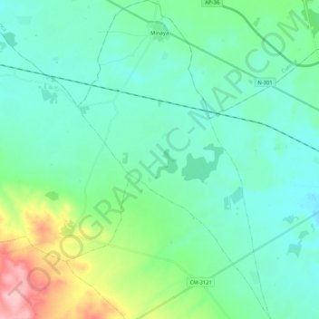
Name: Minaya topographic map, elevation, terrain.

Location: Minaya, Albacete, Castile-La Mancha, Spain (39.12604 -2.37408 39.28611 -2.24918)

Average elevation: 731 m

Minimum elevation: 703 m

Maximum elevation: 838 m

Other topographic maps

Click on a map to view its topography, its elevation and its terrain.

Rio Júcar

Spain > Castile-La Mancha > Cuenca

Average elevation: 955 m

Huelga del Escobar

Spain > Castile-La Mancha > Uña

Average elevation: 1,235 m

El Cobato

Spain > Castile-La Mancha > Cuenca > Huete

Average elevation: 953 m

Aragosa

Spain > Castile-La Mancha > Aragosa

Average elevation: 1,003 m

El Alto

Spain > Castile-La Mancha > Sigüenza

Average elevation: 1,129 m

855

Spain > Castile-La Mancha > Alcantud

Average elevation: 835 m

Gear up for your next adventure:

🔦LED Headtorch - Bright and durable light for night activities
🥾Approach Boots - Comfortable boots for hiking and climbing approaches
🦟Insect Repellent - Keep mosquitoes and black flies away in wooded areas
🚲Bike Repair Kit - Essential tools for on-trail mechanical issues
🥾Hiking Shorts - Breathable shorts suitable for summer hikes

As an Amazon Associate, this site earns from qualifying purchases at no extra cost to you.