Make a donation
Gear up for your next adventure:
As an Amazon Associate, this site earns from qualifying purchases at no extra cost to you.
Richmond Hill topographic map
Click on the map to display elevation.
Make a donation
Gear up for your next adventure:
As an Amazon Associate, this site earns from qualifying purchases at no extra cost to you.
Richmond Hill
The village of Richmond Hill was incorporated by a bylaw of the York County Council on June 18, 1872, coming into effect January 1, 1873. In September 1956, the Ontario Municipal Board approved its elevation to Town status, effective January 1, 1957.
Make a donation
Gear up for your next adventure:
As an Amazon Associate, this site earns from qualifying purchases at no extra cost to you.
About this map
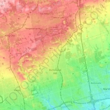
Name: Richmond Hill topographic map, elevation, terrain.
Average elevation: 256 m
Minimum elevation: 171 m
Maximum elevation: 350 m
York Region trails, hiking, mountain biking, running and outdoor activities
Make a donation
Gear up for your next adventure:
As an Amazon Associate, this site earns from qualifying purchases at no extra cost to you.
Other topographic maps
Click on a map to view its topography, its elevation and its terrain.
Make a donation
Gear up for your next adventure:
As an Amazon Associate, this site earns from qualifying purchases at no extra cost to you.
Make a donation
Gear up for your next adventure:
As an Amazon Associate, this site earns from qualifying purchases at no extra cost to you.
Make a donation
Gear up for your next adventure:
As an Amazon Associate, this site earns from qualifying purchases at no extra cost to you.
Make a donation
Gear up for your next adventure:
As an Amazon Associate, this site earns from qualifying purchases at no extra cost to you.
Keswick
Canada > Ontario > York Region
Keswick's geographical coordinates are 44.22°N, 79.45°W, and its elevation above sea level is 221m/762 ft. It has a geographical area of 16.25 km² according to Statistics Canada. It is bound on the north by Roches Point, the east by Woodbine Avenue, the south by East Gwillimbury (Ravenshoe Road) and the…
Average elevation: 228 m
Make a donation
Gear up for your next adventure:
As an Amazon Associate, this site earns from qualifying purchases at no extra cost to you.
Make a donation
Gear up for your next adventure:
As an Amazon Associate, this site earns from qualifying purchases at no extra cost to you.
Make a donation
Gear up for your next adventure:
As an Amazon Associate, this site earns from qualifying purchases at no extra cost to you.
Keswick
Canada > Ontario > York Region
Keswick's geographical coordinates are 44.22°N, 79.45°W, and its elevation above sea level is 221m/762 ft. It has a geographical area of 16.25 km² according to Statistics Canada. It is bound on the north by Roches Point, the east by Woodbine Avenue, the south by East Gwillimbury (Ravenshoe Road) and the…
Average elevation: 228 m
Make a donation
Gear up for your next adventure:
As an Amazon Associate, this site earns from qualifying purchases at no extra cost to you.
Phyllis Rawlinson Park
Canada > Ontario > York Region > Richmond Hill > Gormley
Average elevation: 252 m
Make a donation
Gear up for your next adventure:
As an Amazon Associate, this site earns from qualifying purchases at no extra cost to you.
Whitchurch-Stouffville Community Park, Vandorf
Canada > Ontario > York Region > Whitchurch-Stouffville
Average elevation: 305 m
Make a donation
Gear up for your next adventure:
As an Amazon Associate, this site earns from qualifying purchases at no extra cost to you.
East Holland River
Canada > Ontario > York Region > East Gwillimbury > Holland Landing
Average elevation: 223 m
Make a donation
Gear up for your next adventure:
As an Amazon Associate, this site earns from qualifying purchases at no extra cost to you.
Keswick
Canada > Ontario > York Region
Keswick's geographical coordinates are 44.22°N, 79.45°W, and its elevation above sea level is 221m/762 ft. It has a geographical area of 16.25 km² according to Statistics Canada. It is bound on the north by Roches Point, the east by Woodbine Avenue, the south by East Gwillimbury (Ravenshoe Road) and the…
Average elevation: 228 m
Make a donation
Gear up for your next adventure:
As an Amazon Associate, this site earns from qualifying purchases at no extra cost to you.
