Geolocate

Eustis topographic map

Click on the map to display elevation.

About this map

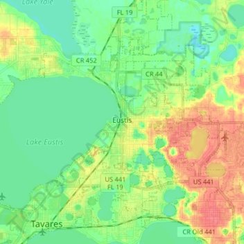
Name: Eustis topographic map, elevation, terrain.

Location: Eustis, Lake County, Florida, United States (28.81103 -81.76213 28.89261 -81.63178)

Average elevation: 28 m

Minimum elevation: 9 m

Maximum elevation: 60 m

Other topographic maps

Click on a map to view its topography, its elevation and its terrain.

Whitney

United States > Florida > Lake County

Average elevation: 25 m

Royal Highlands

United States > Florida > Lake County

Average elevation: 30 m

Mount Plymouth

United States > Florida > Lake County

Average elevation: 25 m

Jacks Lake

United States > Florida > Lake County > Clermont

Average elevation: 54 m

Lake Louisa

United States > Florida > Lake County

Average elevation: 31 m

Gear up for your next adventure:

💡Portable Camping Lamp - Rechargeable lamp for campsite lighting
🔦LED Flashlight - Powerful and long-lasting flashlight for camping and emergencies
🧊Insulated Water Bottle - Keeps drinks cold in summer and prevents freezing in winter
🧥Softshell Jacket - Windproof and breathable jacket for hiking
🔦LED Headlamp - Hands-free lighting for early morning starts or late finishes

As an Amazon Associate, this site earns from qualifying purchases at no extra cost to you.