Geolocate

Altoona topographic map

Click on the map to display elevation.

About this map

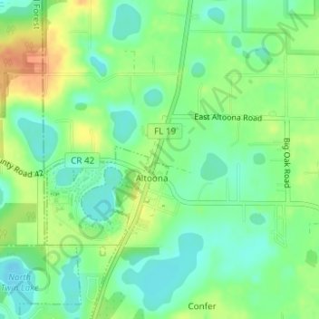
Name: Altoona topographic map, elevation, terrain.

Location: Altoona, Lake County, Florida, United States (28.96034 -81.65446 28.97492 -81.64081)

Average elevation: 28 m

Minimum elevation: 12 m

Maximum elevation: 50 m

Gear up for your next adventure:

🚲Heavy Duty Bike Lock - Secure your bike at the trailhead or during stops
🔦LED Flashlight - Powerful and long-lasting flashlight for camping and emergencies
🏃Hydration Running Vest - Carry water and maps close to your body for speed
Family Camping Tent - Spacious tent suitable for family camping trips
🔋Emergency Crank Radio - Weather alerts and power without needing batteries

As an Amazon Associate, this site earns from qualifying purchases at no extra cost to you.