Geolocate

Taft topographic map

Click on the map to display elevation.

About this map

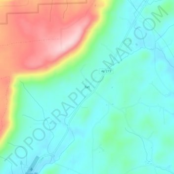
Name: Taft topographic map, elevation, terrain.

Location: Taft, Cherokee County, Alabama, United States (34.32231 -85.64719 34.36231 -85.60719)

Average elevation: 275 m

Minimum elevation: 199 m

Maximum elevation: 454 m

Other topographic maps

Click on a map to view its topography, its elevation and its terrain.

Centre

United States > Alabama > Cherokee County

Average elevation: 177 m

Gaylesville

United States > Alabama > Cherokee County

Average elevation: 181 m

Leesburg

United States > Alabama > Cherokee County

Average elevation: 196 m

Cedar Bluff

United States > Alabama > Cherokee County

Average elevation: 180 m

Cedar Bluff

United States > Alabama > Cherokee County

Average elevation: 179 m

Centre

United States > Alabama > Cherokee County

Average elevation: 177 m

Gear up for your next adventure:

🦟Insect Repellent - Keep mosquitoes and black flies away in wooded areas
🧦Hiking Liner Socks - Thin base layer to prevent friction and blisters
🧊Portable Cooler - Keep food and drinks cold during outdoor adventures
🧢Sun Protection Cap - Breathable cap to protect from sun exposure
👟Trail Running Shoes - Agile footwear for fast-paced topographic exploration

As an Amazon Associate, this site earns from qualifying purchases at no extra cost to you.