
P'yŏngyang topographic map
Interactive map
Click on the map to display elevation.
About this map
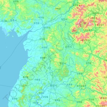
Name: P'yŏngyang topographic map, elevation, terrain.
Location: P'yŏngyang, North Korea (38.79167 125.22261 39.90121 126.40333)
Average elevation: 130 m
Minimum elevation: -2 m
Maximum elevation: 1,190 m
Other topographic maps
Click on a map to view its topography, its elevation and its terrain.
로동
North Korea > Kangwon > Poptong County > 로동
로동, Poptong County, Kangwon, North Korea
Average elevation: 637 m
Imnam Dam
Imnam Dam, Kimhwa County, Kangwon-do, North Korea
Average elevation: 295 m
Paektu Mountain
North Korea > Ryanggang > Samjiyon
Paektu Mountain, Samjiyon, Ryanggang, North Korea
Average elevation: 2,207 m