
Taupō District topographic map
Interactive map
Click on the map to display elevation.
About this map
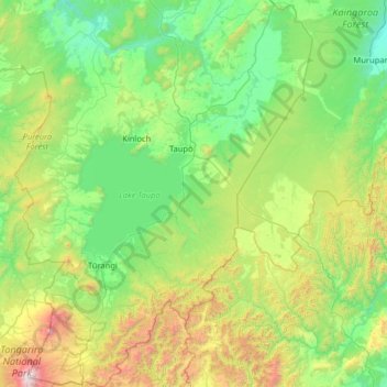
Name: Taupō District topographic map, elevation, terrain.
Location: Taupō District, Waikato, Nouvelle-Zélande (-39.30065 175.51835 -38.30103 176.69771)
Average elevation: 659 m
Minimum elevation: 132 m
Maximum elevation: 2,739 m
Other topographic maps
Click on a map to view its topography, its elevation and its terrain.
Whangamata
Nouvelle-Zélande > Waikato > Whangamata
Whangamata, Thames Coromandel District, Waikato, Nouvelle-Zélande
Average elevation: 20 m
Île du Nord
Île du Nord, South Waikato District, Waikato, Nouvelle-Zélande
Average elevation: 66 m
Waiotapu
Nouvelle-Zélande > Waikato > Waiotapu
Waiotapu, Rotorua District, Waikato, Nouvelle-Zélande
Average elevation: 446 m