
Île du Nord topographic map
Interactive map
Click on the map to display elevation.
About this map
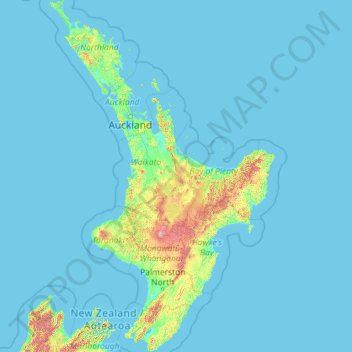
Name: Île du Nord topographic map, elevation, terrain.
Average elevation: 66 m
Minimum elevation: -1 m
Maximum elevation: 2,650 m
Other topographic maps
Click on a map to view its topography, its elevation and its terrain.
Whangamata
Nouvelle-Zélande > Waikato > Whangamata
Whangamata, Thames Coromandel District, Waikato, Nouvelle-Zélande
Average elevation: 20 m
Taupō District
Taupō District, Waikato, Nouvelle-Zélande
Average elevation: 659 m
Waiotapu
Nouvelle-Zélande > Waikato > Waiotapu
Waiotapu, Rotorua District, Waikato, Nouvelle-Zélande
Average elevation: 446 m