Geolocate

Lily topographic map

Click on the map to display elevation.

About this map

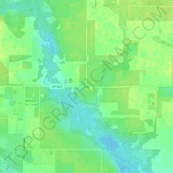
Name: Lily topographic map, elevation, terrain.

Location: Lily, Hardee County, Florida, United States (27.34643 -81.98564 27.38643 -81.94564)

Average elevation: 24 m

Minimum elevation: 15 m

Maximum elevation: 29 m

Other topographic maps

Click on a map to view its topography, its elevation and its terrain.

Wauchula

United States > Florida > Hardee County

Average elevation: 30 m

Peace River

United States > Florida > Hardee County

Average elevation: 25 m

Zolfo Springs

United States > Florida > Hardee County

Average elevation: 20 m

Bowling Green

United States > Florida > Hardee County

Average elevation: 31 m

Wauchula

United States > Florida > Hardee County

Average elevation: 30 m

Zolfo Springs

United States > Florida > Hardee County

Average elevation: 20 m

Bowling Green

United States > Florida > Hardee County

Average elevation: 31 m

Gear up for your next adventure:

🌡️Emergency Mylar Blankets - Compact thermal protection for unexpected nights outdoors
🧦Hiking Socks - Moisture-wicking and comfortable socks for long hikes
🪑Ultralight Camping Stool - Compact seating for rest stops during long hikes
🛌Insulated Sleeping Pad - Critical thermal barrier between you and the cold ground
🧭GPS Handheld Device - Reliable GPS navigation for outdoor adventures

As an Amazon Associate, this site earns from qualifying purchases at no extra cost to you.